

[flipbook id=”47″]
In tomorrow’s edition:
Howe shows strong at Texoma Livestock Show
Weather sets back Bulldogs baseball, but they win two in Bonham on Saturday
60-year-old photos spark emotions from those in them
Howe girl to compete for Miss Texas
Lady Bulldogs All-District honors
Chill Out has sold
Chamber recovers old photos
Photos of Scouts Blue and Gold Banquet and Crossover
Texoma Hot Jobs
Faith by Debbie Wallis
Top Dogs
Learn about your antiques and collectibles
Progress on new chamber office
Front page from 25 years ago this week

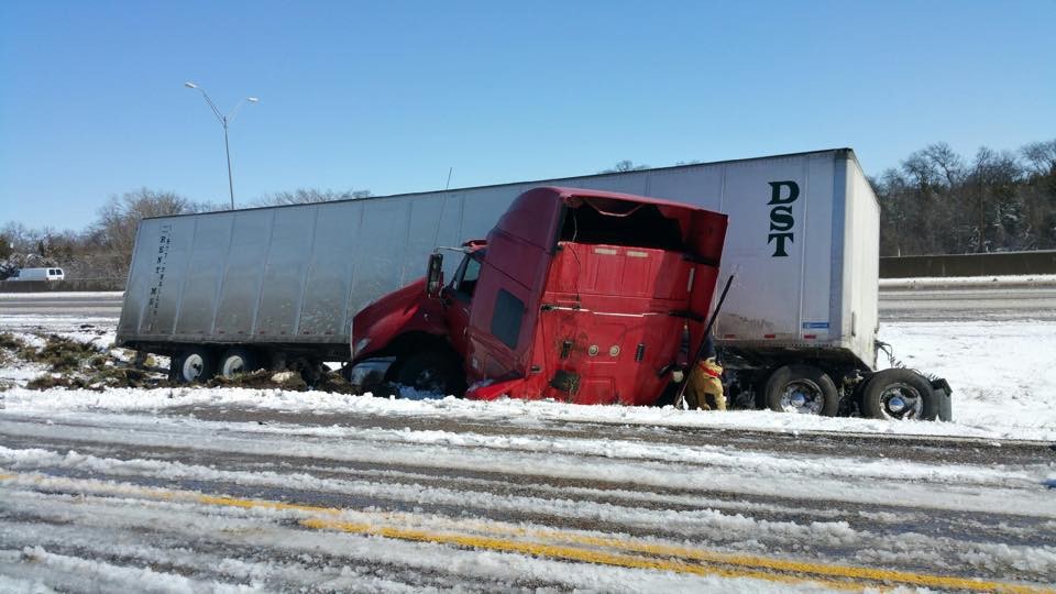
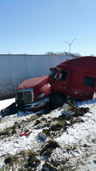
Southbound US 75 accident in Van Alstyne
Howe girl is Miss Lake Worth 2015
Kendall Nelms of Howe has been named Miss Lake Worth 2015. Full story in Monday’s Howe Enterprise.

Howe Police say stay at home for now
Howe Police Sgt Michael Hill says that US 75 is a solid sheet of ice. He says that citizens should stay off the roads if at all possible for the time being. (March 5, 8:15 a.m.)

Roads and weather
TxDOT crews are out plowing, blading and treating roads across the North Texas, working to clear any accumulation of frozen precipitation from the roadways.
As of 6 a.m. today (Thurs., March 5), TxDOT crews are reported clearing skies and temps below freezing district-wide, with two to four inches of snow accumulation overnight. The National Weather Service has most of North and Northeast Texas under a winter weather warning until noon today. Roads will remain hazardous and treacherous until temperatures rebound later today. Bridges, overpasses, etc. will be especially affected.
Howe ISD will be closed tomorrow due to inclement weather
Howe ISD has announced that there will be no school due to inclement weather on Thursday, March 5.

Loy Lake schedule changes for tomorrow due to weather
The Texoma Livestock Show will push back the start times to 12:00 for Ag Mechanics and poultry show. They are still on time for heifer and steer shows.
List of event times:
Thursday, March 5
12:00 p.m. Poultry show, Broilers then Breeding
12:00 p.m. Judge Ag Mechanics Projects
1:00 p.m. Judge breeding Beef
4:00 p.m. Auction of General Exhibit items in the show arena
5:30 p.m. Judge market Steers
7:00 p.m. Deadline to pick up items in Creative Arts Building
10:30 p.m. Lights out
Friday, March 6, 2015
8:00 a.m. Livestock Judging Contest Cancelled
11:00 a.m. Buyer’s Luncheon & Recognition of Life Members
12:00 p.m. Auction Sale
12:00 p.m. Ag Mechanic projects released
Disabled vehicle has traffic diverted in Howe was a stolen vehicle
The Howe Police Department has recovered a stolen vehicle that was disabled. Earlier, the department reported that traffic was diverted by the disabled vehicle.
At 4:20 p.m. – HPD: Northbound traffic on US Highway 75 is being diverted onto The east access road at FM 902 – disabled vehicle is blocking highway.

Photo courtesy of Howe Police Department
Advisory on today’s hazardous roads
The National Weather Service forecasts a winter storm warning and wind advisory for 3 pm today through Thursday at noon. Expect freezing rain, sleet and snow tonight and hazardous road conditions.
Today
Rain before 1 pm, then rain, freezing rain, and sleet. Temperature falling to around 30 by 5pm. Windy, with a north wind 15 to 25 mph, with gusts as high as 30 mph. Chance of precipitation is 100%. Total daytime ice accumulation of less than a 0.1 of an inch possible. Total daytime sleet accumulation of less than a half inch possible.
Tonight
Rain, freezing rain, and sleet before 7pm, then snow and sleet between 7pm and 1am, then snow likely after 1am. Some thunder is also possible. Low around 24. Windy, with a north wind 15 to 25 mph, with gusts as high as 30 mph. Chance of precipitation is 100%. Little or no ice accumulation expected. New snow and sleet accumulation of 1 to 3 inches possible.
TxDOT: Drive safely today. Roads are wet and slick and will be hazardous, especially tonight and tomorrow morning. Check forecasts and road conditions before you travel.
Our crews are out checking/monitoring roads across the TxDOT Paris District, pre-treating roads as needed and working to fix roadway damage from the last storm.
As of 9 a.m. today (Wed. March 4), our crews are reporting light rain and mist across most of the district. The NWS has most of North and Northeast Texas under a winter storm watch and wind advisory, beginning this afternoon at 3 p.m. and extending until Noon on Thursday, March 5. Today’s rain is expected to turn to freezing rain, sleet and snow tonight, with accumulations of 1-3 inches of snow on top of a layer of frozen precipitation by dawntomorrow. Roads will be wet and slick today and will become hazardous tonight. Bridges, overpasses, etc. will likely be affected by freezing rain/sleet first, especially those with no insulation from the ground/earth. Roadways and travel will become more hazardous as the storm progresses. There is also a wind advisory and wind chill advisory in effect with this storm warning. Cold temps and 15-25 mph sustained winds, with gusts of 30-40 mph possible, will make it hazardous to be outside during this weather event. Winds will also affect travel conditions, and make driving even more hazardous. North winds could make travel east or west on area roadways perilous at best.
Please encourage your readers/audience to continue to check local road conditions before they travel, and to use caution when driving today: dress for the weather, drive to road conditions, give other vehicles and our trucks/equipment extra room around your vehicle, be prepared for slick roads, and make sure your vehicle is okay to travel. Stay home tonight and tomorrow morning if at all possible, and use extreme caution if you must get out. Make sure your pets are well cared for this evening/tonight…bring them and cold susceptible plants inside tonight.
”
